
Split a traffic-plan detail map across adjoining sheets when the works will not fit on one page at a readable size.
Use this for a long street or a larger site that needs several printed pages. Choose an XL overview instead when one page showing the whole site is enough. Sheet layouts are not available in event plans.
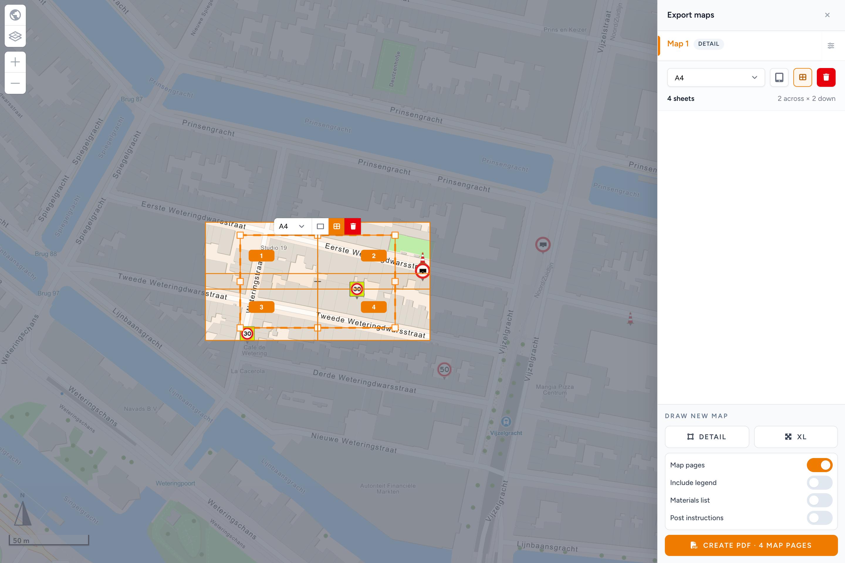
Create the sheet layout
- Open your editable traffic plan and choose Export. Continue to the file export so Export maps opens.
- Under Draw new map, choose Detail and draw a rectangle over the works. You can also select an existing Detail map.
- Select the rectangle. In its floating toolbar, choose Paper size and use Change orientation if needed. A4 is the starting format; you can select another available paper size.
- Choose Split across sheets, the grid icon in the floating toolbar or the export row. The first layout has one sheet and keeps the current map detail.
- Drag a corner of the rectangle outwards to include more of the works. The grid adds sheets instead of making the signs smaller. The export row shows the number of sheets and the columns and rows.
- Check the grid on the map. Every junction and sign needed for the handover should be inside the selection. You can still change Paper size or Change orientation with the grid on. Both recalculate the sheet layout while preserving the selected area and map detail.
- Include the map in the export and choose Create PDF with the displayed map-page count. Wait for the download and inspect every page.
The map grid and the downloaded PDF use the same page layout. Moving or enlarging the selection changes its coverage. Merely zooming the editor does not add sheets. There are no separate scale, overlap or margin settings for this tool.
Selecting an export map shows only that map's grid; selecting an ordinary map temporarily hides the other grids. They have not been deleted. Click the map outside export rectangles and their handles to clear the selection and see the grids again.
Print and assemble
For cell references such as C3 on each PDF sheet, use the PDF reference grid. This overlay does not change the sheet layout.
Print from your PDF viewer at 100% or actual size, single-sided. Turn off fit-to-page and borderless scaling: those options change the printed scale.
The footer identifies each sheet and its row and column. Place the side edges together. Overlap the top and bottom edges using the repeated map strip; trim or fold away the header and footer bands if needed. Follow the assembly instruction printed on the sheets.
A layout with one sheet does not need assembly instructions. Page padding can show map content just outside the rectangle you selected, so check the outside edges too.
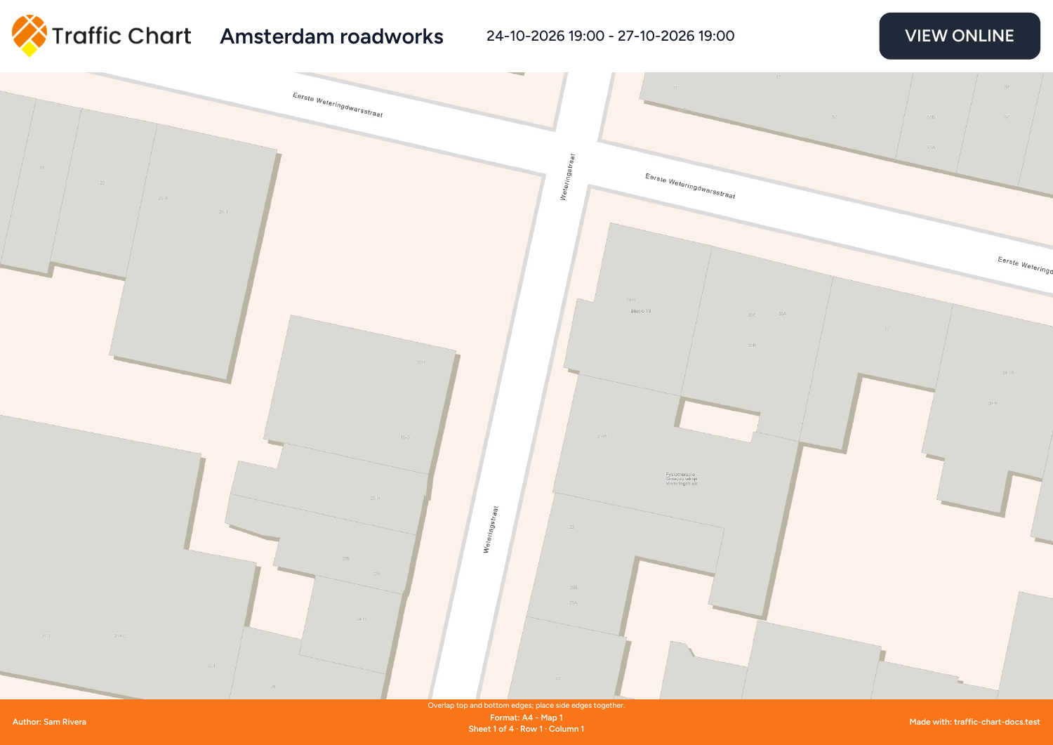
An actual example export, sheet 1 of 4. The other sheets continue the same map.
Return to one sheet
Select the map and choose Use one sheet. The rectangle returns to the ordinary paper proportions and size limits. If you switch the grid on again during the same editor session without changing the ordinary selection, the previous layout returns. After changing that selection or reopening a disabled grid, start again with one sheet.
Save the plan before closing it. An enabled layout is retained when you save and reopen the plan, duplicate it or transfer it through a backup.
To switch this map to an XL overview instead, choose Use one sheet first. Export type becomes available again; choose XL if your account allows it.
Limits and blocked exports
| Situation | Next action |
|---|---|
| The area needs more than 100 sheets | Reduce the selected area or choose a larger paper size. |
| The complete PDF would exceed 100 map pages | Select fewer maps, reduce an area or use larger paper. The limit includes the other map pages in the same export. |
| Splitting across sheets is temporarily unavailable | Use Use one sheet, or exclude that map from this export. The saved grid is retained for later. |
| The print area is invalid | Draw a new rectangle. |
| The selected map or paper does not support this layout | Choose a supported paper size or return to one sheet. Use the default map if the map projection is unsupported. |
| PDF creation takes longer for a large layout | Keep the tab open. Use Stop export if you need to cancel; cancellation does not download a partial PDF. |
If required signs or map content cannot finish rendering, the export can fail rather than give you an incomplete map. Wait for the editor to load, try a smaller export and contact support with the plan link if it keeps failing. Export troubleshooting.
Check the result
Open every PDF page. Confirm the paper format, signs, labels, sheet positions and adjoining map edges. A screen preview cannot confirm your printer settings; check a pair of printed sheets before printing a large set. Map scale is not a surveying guarantee over a very large area.